During this year’s excavation at Fort Hunter (2016), the State Museum of Pennsylvania was fortunate
enough to have a survey crew from PennDOT perform LiDAR
scans of the milk house structure and surrounding excavation units. Partnering
across agencies provided an opportunity for PennDOT to establish a new bench mark
for highway use and for archaeologists to utilize modern technology not
available within the Pennsylvania Historical and Museum Commission.
What is LiDAR?
LiDAR, a form of 3D scanning, is
a method for creating a 3D model of an object, structure or environment. A LiDAR
scanner (seen in the image below) bounces millions of points of light off of objects
in its path, measuring distance and position. By collecting data on millions of
points, a three dimensional point cloud is created which can be processed into
a 3D model. PennDOT uses LiDAR to create highly accurate renderings that can be
used in the management of Pennsylvania’s roads and bridges. Our excavations at
Fort Hunter were scanned using Terrestrial LiDAR.
This form of LiDAR, involves setting up the LiDAR scanner in several stationary
positions around the site or structure to be scanned. Aerial LiDAR has aided
in the discovery
of long forgotten archaeological sites obscured by jungle overgrowth. These
two types of LiDAR differ not only in their scanning method, but also in the resolution
and applications of the data they produce. Terrestrial LiDAR provides more
accurate and detailed models of smaller areas than aerial LiDAR, which makes it
an especially useful tool in examining features at Fort Hunter.

PennDOT
surveyors prepare the terrestrial LiDAR scanner adjacent to the milk house.
Image: PHMC/Melanie Mayhew
At Fort Hunter, the survey crew
used terrestrial LiDAR to create detailed and precise 3D maps of structures and
our excavations. The scans of Fort Hunter are comprised of over an estimated
100 million points. Our main objective was to capture information about the milk
house and smoke house features, but additional data was also captured.

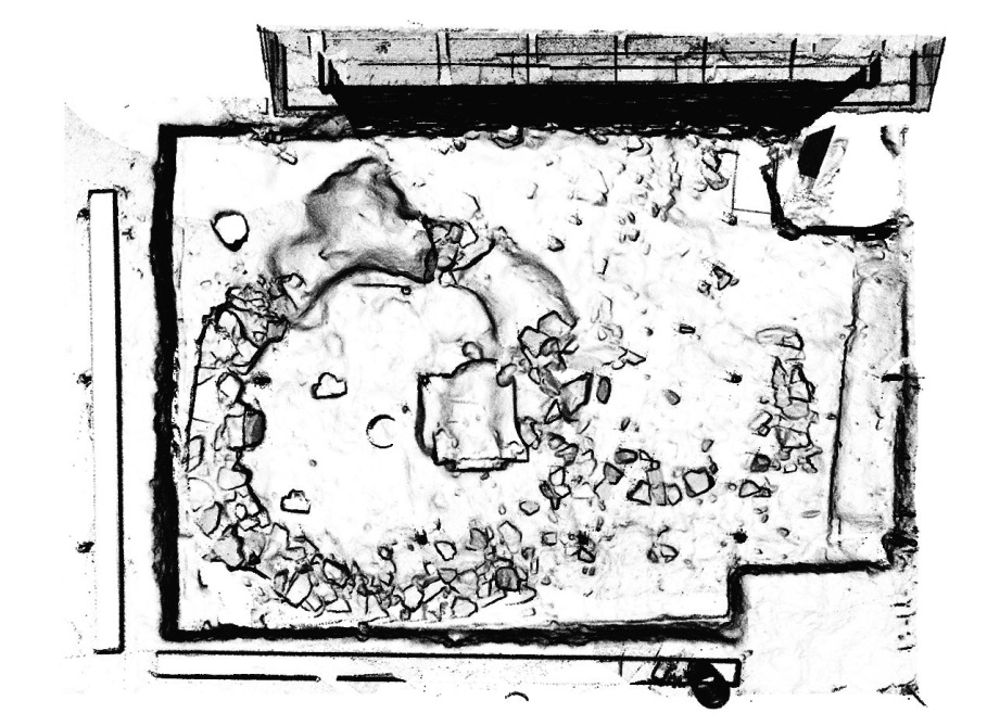
LiDAR
scan of Fort Hunter, note the black areas are where the laser’s path was
blocked from reaching the structure. Note the milk house in the lower right
corner of the image. Image: PennDOT/Photogrammetry & Surveys Section
As you can imagine, it is
impossible to capture all of the three dimensional data at an archaeological
site using photographs and hand drawn maps. Terrestrial LiDAR creates a map with
far more detail and precision than can be created by hand. The processed LiDAR
scans that resulted from this endeavor can be rotated 360 degrees, viewed under
multiple filters, and a video can even be made to appear as if you are moving
through the scanned site. Millimeter-accurate measurements can be made between any
points in the model.

This
rendering of the milk house at Fort Hunter can be used to take measurements,
create images, videos or 3D printed models. Image: PennDOT/Photogrammetry &
Surveys Section
How will these scans be used?
The digital data created by the LiDAR
scans will become part of the site’s collected documentation, and it has the
ability to greatly enhance the archaeological record without using additional
shelf space. In the image below, you can see a circular stone foundation of
what is believed to be an octagonal smoke house adjacent to the structure we
refer to as the milk house. The survey crew was able to scan both the interior
and exterior of the milk house, creating a 3D replica of the structure as it
exists today. Because archaeology is a destructive process, and because it is generally
not practical to leave excavations open indefinitely, LiDAR scans provide an
excellent opportunity to digitally recreate a structure or three dimensional
feature long after fieldwork has concluded.

Two
images of the smokehouse’s foundation produced from PennDOT’s LiDAR scan at
Fort Hunter. The scans can be viewed from any angle and filters can be applied
to change the appearance of the images. Image: PennDOT/Photogrammetry &
Surveys Section
The images and data from these
scans will provide enhanced interpretive material for future exhibits, and
carry forward our goal of educating the public about Pennsylvania’s archaeology.
The State Museum of
Pennsylvania’s Section of Archaeology would like to extend a big Thank You to
PennDOT’s Photogrammetry & Surveys Section for lending their time and
talents to provide us with this data.
Please
visit our gallery of Anthropology and Archaeology on the second floor of The
State Museum of Pennsylvania where you can view additional artifacts
representing our archaeological heritage. Look for an updated exhibit on our
investigation at Fort Hunter Mansion and Park in the spring of 2017.
No comments:
Post a Comment